DRONE TECHNOLOGY
Relevance – GS2 International Relations , GS3 Science and Technology , Prelims Context – Extensive use of drones in India – Pakistan conflict
WHAT ARE UAVs?
Unmanned aerial vehicles (UAVs) are aircraft that operate without onboard crew or passengers. They can function as automated ‘drones’ or be controlled remotely as piloted vehicles (RPVs).Originally developed for military reconnaissance and combat operations but now have many civil applications in agriculture , infrastructure , disaster management etc.
CIVIL APPLICATIONS OF UAVs
1. Land Survey and Property Mapping
- Application: Cadastral mapping, land record digitization
- Example:
- SVAMITVA Scheme (2020–present):
- Drones used to map rural inhabited lands for providing property cards (ownership records).
- SVAMITVA Scheme (2020–present):
2. Agriculture & Precision Farming
- Application: Crop monitoring, pesticide spraying, yield estimation.
- Recent Example:
- In Punjab & Haryana, drones are being used for spraying nano urea and monitoring crop health.
- Digital Sky Platform + FPOs (Farmer Producer Organizations) enabled to lease drones under Custom Hiring Centres.
3. Disaster Management & Emergency Response
- Application: Search and rescue, damage assessment, delivery of emergency supplies.
- Recent Example:
- Uttarakhand Tunnel Collapse (Nov 2023): Drones were used to assess trapped worker conditions and deliver food packets.
- Cyclone Yaas (2021): NDMA used drones for flood monitoring and rescue planning.
4. Healthcare & Medicine Delivery
- Application: Delivery of vaccines, blood, medicines to remote areas.
- Recent Example:
- i-Drone initiative by ICMR (2021–ongoing): Used to deliver COVID-19 vaccines to remote areas in Manipur, Nagaland, and Andaman & Nicobar Islands.
5. Forest and Wildlife Monitoring
- Application: Anti-poaching surveillance, forest fire detection, wildlife tracking.
- Recent Example:
- Jim Corbett National Park: Drones used to track tiger movement and monitor forest fires.
7. E-commerce and Logistics
- Application: Drone-based delivery of consumer goods.
- Recent Example:
- Swiggy and Dunzo trials in Bengaluru and Hyderabad (2022–2023) to deliver food and medicine via drones.
DRONE RULES 2021
Promote ease of doing business in the drone sector. Encourage indigenous R&D, manufacturing, and adoption under Atma Nirbhar Bharat. Balance innovation with security (esp. India-Pak border, critical infrastructure).
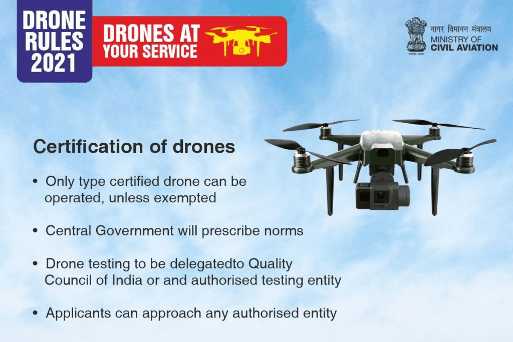
- Simplified Certification:
- Reduced paperwork: Type Certificate, Unique ID, Remote Pilot License only.
- Abolished need for security clearance, import permits, and operator permits.
- No-Permission-No-Takeoff (NPNT):
- Mandatory digital permission via Digital Sky Platform for all flights.
- Green Zones:
- No permission needed for drones <500 kg in areas up to 400 ft altitude.
- Covers 90% of Indian airspace (e.g., rural, non-sensitive urban areas).
- Red/Yellow Zones:
- Restricted near airports, borders (e.g., India-Pak LoC), military sites
DRONE CATEGORIES
| Class | Weight | Example Use |
| Nano | <250g | Hobbyist photography |
| Micro | 250g–2kg | Delivery (e.g., medicine in NE) |
| Small | 2kg–25kg | Agriculture spraying |
| Medium | 25kg–150kg | Surveillance (e.g., LoC) |
| Large | >150kg | Heavy payload (military/logistics) |
KAMIKAZE DRONES
- Definition: Loitering munitions designed to hover(6-24 hours) over a target area, detect threats, and destroy targets by crashing into them (self-destruct mechanism).
- Origin: Term “kamikaze” derives from WWII Japanese suicide pilots; modern versions are autonomous or remotely guided.
- Key USP: Combine surveillance + strike capabilities in a single system.
- Also known as switchblade drones due to their bladelike wings that spring out on launch.
| Feature | Details |
| Role | Surveillance + Precision Strike |
| Type | Suicide drone (loiters and explodes on target) |
| Speed | Subsonic, varies by model |
| Range | Short to medium (5 km to 200+ km depending on drone) |
| Payload | High-explosive warhead |
| Control | Human-in-loop or AI-enabled target recognition |
TYPES OF KAMIKAZE DRONES
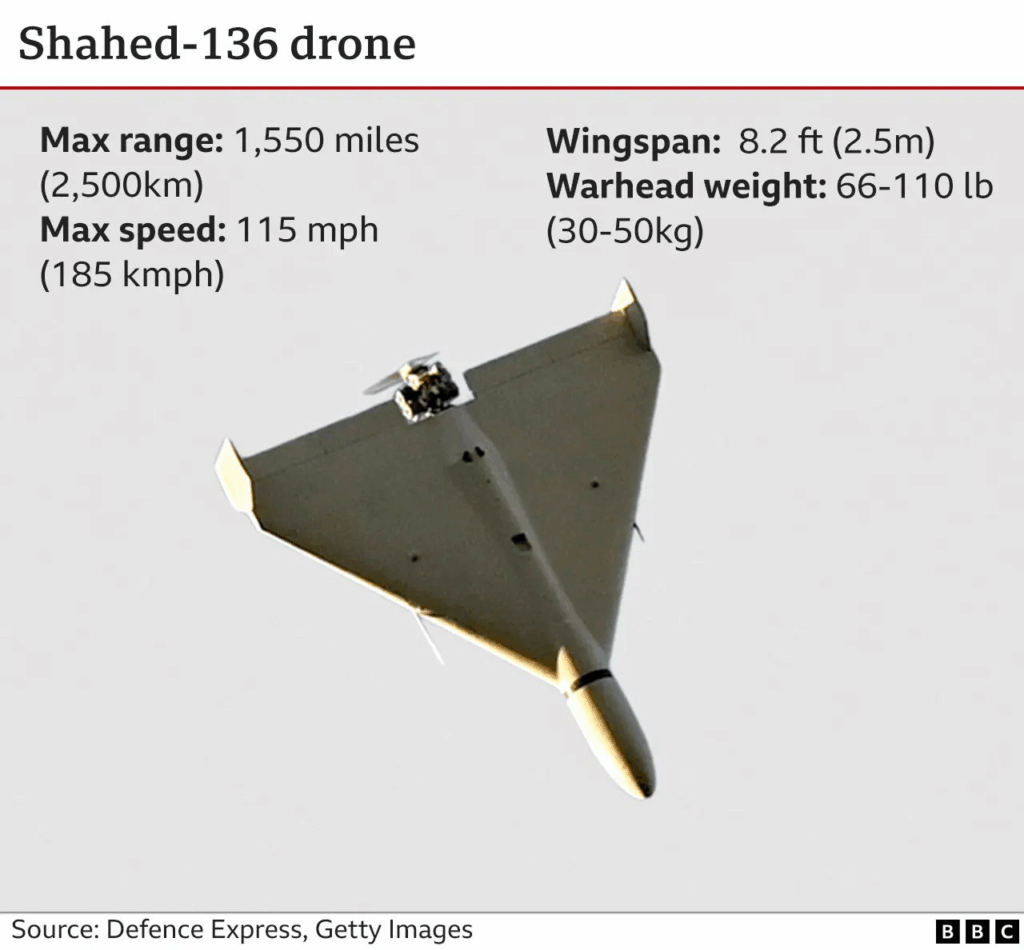
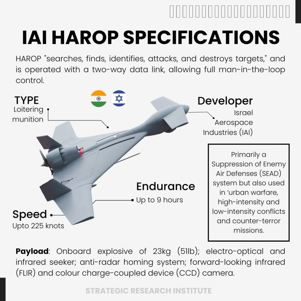
| Name | Country | Key Features | Used By |
| Harop | Israel | 1,000 km range; anti-radar capability | India, Azerbaijan |
| Switchblade | USA | Portable (2–5 kg); 10–40 km range | US Army, Ukraine |
| Shahed-136 | Iran | 2,000 km range; used by Russia in Ukraine | Russia, Houthis |
| Warmate | Poland | Low-cost; integrates with NATO systems | Poland, UAE |
| Nagastra-1 | India | Indigenous; 30 km range; parachute recovery | Indian Army (2023) |
YOU SHOULD ALSO KNOW : LOITERING MUNITIONS
- Definition: Aerial drones with built-in explosives that “loiter” (wait) near a target zone, identify threats, and destroy targets by crashing into them (suicide attack).
- Passive Surveillance: Can hover for hours (e.g., 6–24 hrs) to scan areas.
- Precision Strike: Abort or redirect mid-flight for minimal collateral damage.
- Cost & Risk Reduction: Avoids deploying expensive jets/soldiers near hostile zones.
- Swarm Capability: Deploy in groups to overwhelm enemy defenses.
- 1980s Origin: Designed for SEAD missions (Suppression of Enemy Air Defenses) to destroy SAMs (Surface-to-Air Missiles).
- Post-2000s: Expanded roles in counter-terrorism (e.g., targeting hidden militants).
- 2020s: Integrated with AI and swarms for modern warfare (e.g., Ukraine conflict).
TURKISH DRONES TO PAKISTAN : SONGAR DRONES

- The drone’s rotor-to-rotor width is 140 cm, with a maximum take-off weight of 45 kg.
- It can perform operations for 35 minutes without payload, and has autonomous and manual flight control modes.
- Operational range is approximately 10 km, with a maximum altitude of 3,000 m above mean sea level and 300 m above ground level.
- Equipped with real-time video transmission and dual cameras – a pilot camera for navigation and a gun-mounted camera for targeting.
- Includes GPS and GLONASS-based navigation, with autonomous return-to-base function in case of communication loss.
PRELIMS PRACTICE QUESTION
Question. With reference to drones in India, consider the following statements:
- The use of drones for commercial purposes is completely prohibited in India.
- The Digital Sky Platform is an initiative of the Ministry of Defence to regulate drone traffic.
- Nano drones (less than or equal to 250 grams) do not require registration or permission to fly in India.
Which of the statements given above is/are correct?
A. 1 and 2 only
B. 3 only
C. 2 and 3 only
D. 1, 2 and 3
Answer: B
MAINS PRACTICE QUESTION
Question: Discuss the emerging role of drones in modern warfare with special reference to India’s security challenges ?(150 words, 10 Marks)
Also Read NEW BRAHMOS MISSILE FACILITY